Sectional Chart Airspace Classification Overview

There are 6 different classifications for airspace and each of them have a different way of being marked on a sectional chart. In this article, were going to walk through the different classes of airspace.
This looks confusing at first, but breaking each airspace down and understanding it's parts make reading the sectional pretty easy.
There are also 'special use', like Military Operation Areas, Controlled Firing Areas, erc and 'other airspace', like Temporary Flight Restrictions, Military Training Routes, Parachute Jump Aeras, erc. Knowing what airspace you're flying in is important - but checking a map to see if there are any special conditions are also important.
In this article, were only going to be looking at the different classifications of airspace. If you have any questions about airspace, join our Drone Community Facebook Group and ask!
Here is the airspace legend from the sectional chart that are going to be covering in this article.

Class A Airspace Overview
As a drone pilot, you'll never be flying in class A airspace.
Refer to the main image above, showing class A airspace in red above all other airspaces.
Just know that class A airspace is for airplanes that are traveling long distances at 18,000+ feet MSL. As a drone pilot, we never come close to flying in class A airspace, but it's important to know that what it is because you'll be asked questions about it on your part 107.
Class B Airspace Overview
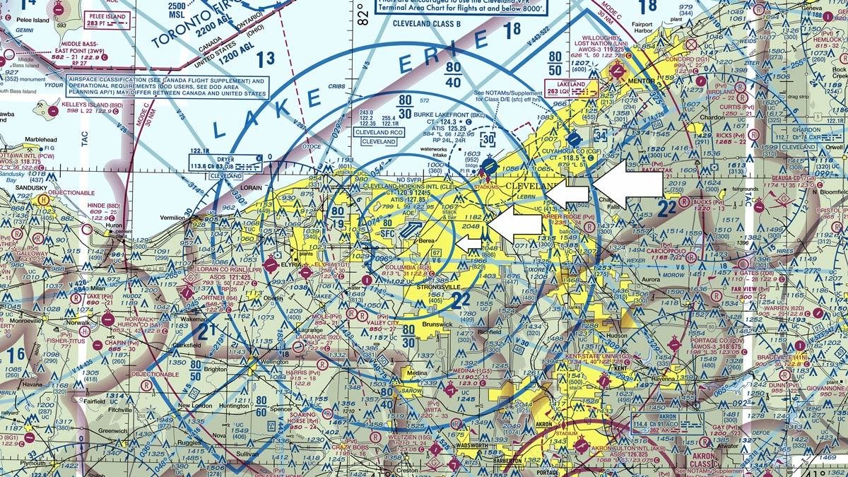
Class B Airspace, indicated by a solid blue line.
Class B airspace is shown with a solid blue line around major airports in circles radiating outward. In the example above, the white arrows are pointing to each circle of the class B airspace.
Each of these circles have different elevations that create an "upside down wedding cake" with each 'layer' of circles. The center circle around the airport typically starts at the surface and extends all the way up to the top of the airspace. There are usually at least 2 other shelfs of circles. As the circles move further away from the center airport, the floor of the airspace increases, while the ceiling of the airspace remains the top of the airspace.
Class B Airspace is measured in Mean Sea Level (MSL).
Class B Airspace is controlled airspace, so you'll need to have authorization to fly here. Typically it's hard to get approval to fly in this airspace.
Class C Airspace Overview

Class C Airspace, indicated by a solid magenta line.
Class C Airspace shows up on the map around larger airports as a solid Magenta line. They have a layer similar to class B airspace, but on a smaller scale and typically with only one other shelf.
In the above example, the center Class C Airspace begins at the surface up to 5,200 feet. The outer Class C Airspace begins at 2,500 feet and extends up to a ceiling of5,200 feet.
Class C Airspace is controlled airspace and you'll need to have authorization to fly here.
Class D Airspace Overview

Class D Airspace, indicated by the dashed blue line.
Class D Airspace is around medium-sized airports and typically has a blue number inside of a blue box. In the example image above, the blue number in the box is 30, meaning the airspace ceiling extends up to 3,000 feet.
Since there is a "-" symbol in front of the blue 30, it would mean the airspace ceiling extends up to by not including 3,000 feet.
Class D Airspace is controlled airspace and you'll need to have authorization to fly here.
Class E Airspace Overview

Class E Airspace, indicated by the faded magenta line.
Most of the airspace in The United States is Class E airspace. Class E airspace extends from 1,200 feet AGL to 17,999 feet MSL (18,000 feet is the floor of Class A airspace). Class E airspace can also extends down to the surface or 700 feet AGL. Sounds confusing - right?
When Class E airspace extends down to 700 AGL, the sectional shows a faded magenta line (not a solid magenta line like Class C Airspace).
When Class E Airspace extends down to the surface, the sectional shows a faded magenta line (thats the 700 AGL to 17,999 MSL) but will also show a dashed red circle. This is where the Class E Airspace extends from surface level all the way up to 17,999 feet.
Class E Airspace is controlled airspace and you'll need to have authorization to fly here.
Class G Airspace Overview
Class G Airspace is all other airspace under 14,500 feet and is uncontrolled airspace. Class G Airspace does not require any authorization to fly in, assuming there are no TFR's or other special restrictions.
Conclusion
Those a the classifications of airspace in The United States - they can be overwhelming at first when you don't understand the different classifications, but once you know what to look for and read the legend they start to make more sense.
Check out our other articles about the Part 107 and reading sectional charts below!